About Point Clouds
 Point clouds are created by 3D scanners.
These devices measure a large number of points on an object's surface,
and output a point cloud as a data file. The point cloud
represents the set of points that the device has measured. The large number of data points results in a high information content;
this allows for a quick and detailed depiction of complex objects.
Point clouds are created by 3D scanners.
These devices measure a large number of points on an object's surface,
and output a point cloud as a data file. The point cloud
represents the set of points that the device has measured. The large number of data points results in a high information content;
this allows for a quick and detailed depiction of complex objects.In architecture it is used mainly for site measurements of buildings. This is especially interesting for older buildings that often do not exhibit any regular geometric features. Difficult to access objects such as facades and roof constructions can be efficiently dealt with using laser scanning.

About OrthoGraph Floor Plans
A floor plan is a drawing to scale, showing a view from above, of the relationships between rooms, spaces and other physical features at one level of a structure.OrthoGraph Floor Plans contain the outlines of the buildings / rooms. Floor plans are good when you would like to calculate with area , perimeter and other metrics or you would like to see the structure of a building . Floor plans are also the official formats in real estate business, in interior design or in architecture. Simple floor plans can be also indispensable for painters, tilers and for other craftsmen.
| Point Clouds | OrthoGraph Floor Plans | |
|---|---|---|
| Great forreval hidden details | x | |
| Great for seeing the structure of a building | x | |
| Small, easy to send file size | x | |
| Official format in many professions | x | |
| Good for understand different layers | x |
Use Point Clouds in OrthoGraph
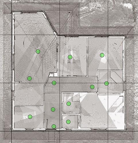
Did you know that OrthoGraph can handle special point clouds? If you Use Point Cab, it can create sectional views which can be uploaded to OrthoGraph as a background picture. Using such an accurate background picture can ease your work. For example, you don't have to calibrate point cloud pictures like other backgrounds, as these point cloud files contain dimensional data. If you have a point cloud file it is just a few click to create a 100% accurate floor plan with instant reports and PDF room books.More information about floor plans:
http://www.laserscanning-europe.com/en
More information about OrthoGraph:
http://www.orthograph.net/
Your OrthoGraph Team
No comments:
Post a Comment